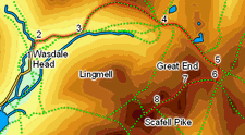
 This walk takes us up through some of the most dramatic mountain scenery in the Lake District, visits Sprinkling Tarn in its dramatic isolation below the crags of Great End, before brings us to the summit of the highest mountain in England. On a clear day the views are majestic on every step from Wasdale to the summit of Scafell Pike.
This walk is not really suited to a foggy day - the rocky Scafell ridge is difficult to negotiate in poor visibility.
Ascent: 3,571ft
Length: 9.3 miles
Map: Lakes South West
Last Walked: August 2007
We start in the car park in front of the Wasdale Head Inn. Pass to the right of the inn, heading towards Mosedale Beck. Just before the beck, turn right and follow the signposted path that runs between the buildings of Wasdale Head and the beck.
![]() We follow this path until it crosses Fogmire Beck. Turn right onto the path that runs alongside this minor beck to Burnthwaite farm. Just beyond the farm the path leaves the side of this beck and continues along the base of valley, heading towards Lingmell Beck.
We follow this path until it crosses Fogmire Beck. Turn right onto the path that runs alongside this minor beck to Burnthwaite farm. Just beyond the farm the path leaves the side of this beck and continues along the base of valley, heading towards Lingmell Beck.
![]() Just under half a mile after passing the farm, this path crosses Gable Beck on a substantial footbridge. Ignore the path that branches off to the left just past this beck (this path leads up to Napes Needle on the slopes of Great Gable). Instead continue along the valley bottom path for another 800 feet. This brings us to another junction, where a minor path continues along the valley bottom while our path turns slightly to the left and begins the climb up towards Sty Head. Take this left hand branch (Moses Trod) and follow it all the way to the top of the pass.
Just under half a mile after passing the farm, this path crosses Gable Beck on a substantial footbridge. Ignore the path that branches off to the left just past this beck (this path leads up to Napes Needle on the slopes of Great Gable). Instead continue along the valley bottom path for another 800 feet. This brings us to another junction, where a minor path continues along the valley bottom while our path turns slightly to the left and begins the climb up towards Sty Head. Take this left hand branch (Moses Trod) and follow it all the way to the top of the pass.
![]() At the top of the climb we reach Sty Head. Here a ridge of high ground separates Wasdale from Sty Head tarn. Turn right and follow the path that runs along this high ground, heading due east. To our right is the northern flank of Great End, and the start of the corridor route up Scafell Pike, while straight ahead is a major path, complete with
At the top of the climb we reach Sty Head. Here a ridge of high ground separates Wasdale from Sty Head tarn. Turn right and follow the path that runs along this high ground, heading due east. To our right is the northern flank of Great End, and the start of the corridor route up Scafell Pike, while straight ahead is a major path, complete with ![]() stone steps, which climbs up alongside the ravine formed by the small beck that runs out of Sprinkling Tarn. Follow this path alongside the stream.
stone steps, which climbs up alongside the ravine formed by the small beck that runs out of Sprinkling Tarn. Follow this path alongside the stream.
Our path passes to the right of Sprinkling Tarn, dips down into the valley of Ruddy Gill, and then climbs up towards Esk Hause, running to the right of the dramatic gorge of Ruddy Gill.
![]() After climbing steeply for a quarter of a mile our path reaches another path. Turn right onto this path and follow it up onto the ridge between Great End and Scafell Pike.
After climbing steeply for a quarter of a mile our path reaches another path. Turn right onto this path and follow it up onto the ridge between Great End and Scafell Pike.
Despite the thousands of people who walk across the ridge every year, no clear paths cross the rough rocky surface of this ridge. Our route is marked by a reasonably clear line of cairns, and on clear days by the line of walkers visible ahead and by Scafell Pike itself. On a foggy day it can become very indistinct.
![]() The path from Esk Hause reaches the top of this ridge and then turns left, crossing a wilderness of boulders as it passes to the right of a rocky outcropping. This stretch is followed by an easier patch, on the relatively boulder-free top of Ill Crag. Here the path is visible on the ground,
The path from Esk Hause reaches the top of this ridge and then turns left, crossing a wilderness of boulders as it passes to the right of a rocky outcropping. This stretch is followed by an easier patch, on the relatively boulder-free top of Ill Crag. Here the path is visible on the ground,
![]() This path eventually drops down into the gap between Ill Crag and Broad Crag. At the bottom of his drop the path turns slightly to the left and heads around the left hand side of Broad Crag, The correct route curves gently around to the right, climbing slightly, and is marked by cairns built precariously on the rocks. In clear weather the best guide is the bulk of Scafell Pike but in heavy fog take care not to head too far up onto Broad Crag.
This path eventually drops down into the gap between Ill Crag and Broad Crag. At the bottom of his drop the path turns slightly to the left and heads around the left hand side of Broad Crag, The correct route curves gently around to the right, climbing slightly, and is marked by cairns built precariously on the rocks. In clear weather the best guide is the bulk of Scafell Pike but in heavy fog take care not to head too far up onto Broad Crag.
This path eventually drops down into the gap between Broad Crag and Scafell Pike itself.