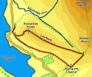
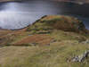
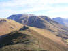
 This short walk takes us up Rannerdale Knotts, a dramatic rocky ridge that overlooks the southern end of Crummock Water, and that runs south-east towards Buttermere, providing fantastic views down the valley and up towards Great Gable.
Ascent: 1,050ft
Length: 2.5 miles
Map: The English Lakes - North Western Area (OS Explorer Map Active)
Last Walked: February 2010
We start from the small car park at the northern end of Rannerdale Knotts, sheltering under the crags at the end of the fell.
1: NY 163 183
Turn left out of the car park onto the road. After a short distance take the path that climbs up the side of the fell towards Hause Point. This route was once the main road into Buttermere from Crummock Water.
2: NY 163 181
At the top of the climb the path branches - the main path over into Buttermere crosses a swampy patch and begins to drop down, while a rather more visible path branches off to the left, climbing up the side of the fell. Take this left-hand path,
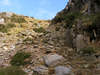
which soon climbs up onto another shoulder on the fell-side. Here a minor path continues on in the same direction, while a clearer path heads off to the left. Take this left-hand path and follow it as it climbs up a gap in the crags, crossing a minor stream as it goes (the steepest parts of this path have been given stone steps). Eventually this path brings us onto the top of the ridge.
3: NY 166 183
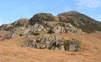
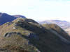
Turn right onto the path that runs along the ridge, and follow it as it climbs over a series of easy rocky outcrops.
4: NY 179 177
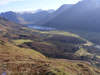
Eventually this path brings us to the end of the ridge, where it merges into Whiteless Breast. A number of paths head down from here towards Buttermere. Take the right-hand path, which runs to the right of a rocky ridge, and gives the best view of our path onwards. Follow this path down until it approaches Grassgarth Coppice, a small wooded area.
5: NY 176 174
Just before reaching the trees turn right onto any one of a series of paths that cut across the hillside, soon merging into a single path that runs along the upper edge of the woods. According to the OS Map when this path reaches the end of Great Wood it turns left and drops down to the road, but that is no longer the case - instead follow this path as it runs along the middle slopes of Rannerdale Knotts, eventually joining up with the path across Hause Point just beyond the point we left it at. Follow the path down from Hause Point back to the road and our starting point.