 Loughrigg is one of the shorter fells, just over 1,000ft high, but its position is superb - it is only linked to higher ground to the west, and even there a deep valley separates it from a ridge that leads up to the Langdale Pikes. It's location means that it's a great viewpoint, with Grasmere, Rydal Water, Ill Bell, Windermere and the Langdale Pikes all in site.
This walk does leave the main footpaths on the summit of Loughrigg, and instead follows some clear but minor paths that roughly follow the course of the un-named stream that flows north-east from the small tarn near the summit. Don't do this walk if you aren't confident off the main paths.
Ascent: 1,250 ft/ 390m
Length: 4 miles/ 7km
Map: Explorer 07 - English Lakes South East
Last Walked: 9 October 2007
We start from the former NT car park at White Moss Common (since taken back by the land owners and now a pay and display car park).
![]() Cross the bridge, which leads to three paths. Two follow the river, and the third leads away from the river into the trees. Follow this third path.
Cross the bridge, which leads to three paths. Two follow the river, and the third leads away from the river into the trees. Follow this third path.
The path continues on from the summit, first dropping down from the summit itself, which is raised above the general level of the broad level of the fell, and then down a steep slope into a small valley.
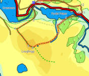
![]() This is the point at which we leave the main path, and take to the maze of small paths that cross the summit area. Our target is to follow the general route of a small beck that runs north-east off the fell, aiming for Rydal Water.
This is the point at which we leave the main path, and take to the maze of small paths that cross the summit area. Our target is to follow the general route of a small beck that runs north-east off the fell, aiming for Rydal Water.
![]() About 400ft from the summit cairn, at the base of the second drop, a small path branches off to the left. Follow this path to a small tarn, then along the left-hand side of the tarn. This brings us to a crossroads, where we head straight across, and then down a steep slope onto a swampy plateau called Scartufts.
About 400ft from the summit cairn, at the base of the second drop, a small path branches off to the left. Follow this path to a small tarn, then along the left-hand side of the tarn. This brings us to a crossroads, where we head straight across, and then down a steep slope onto a swampy plateau called Scartufts.
Head north-east across the plateau, generally following the direction the water is flowing. At the far side of the plateau a stream comes together, and heads down the fell, accompanied by a clearer path. Follow this path for about a quarter of a mile.
Eventually the small stream joins a larger one that runs down a clear valley, heading towards Rydal Water. Ignore a path that runs alongside this second stream and instead follow our path as it climbs out of this little valley. We then reach a crossroads, where we turn left and follow a clear path down to Rydal Water.
We reach the major tourist path around Rydal Water in a group of large trees. Turn right onto this path. with trees to the right and and open ground heading down to the lake to the left.
This path runs through some trees until it reaches a bridge over the river. Cross this bridge and follow the path up to Rydal village, where we join the main road. Turn right and head along the road for a short distance.
![]() Just after passing Rydal Mount turn left onto a signposted footpath. Follow this path as it runs across the lower slope of Heron Pike, until we reach the western end of Rydal Water.
Just after passing Rydal Mount turn left onto a signposted footpath. Follow this path as it runs across the lower slope of Heron Pike, until we reach the western end of Rydal Water.
After about a mile on this path we reach a small cottage. At this point turn left onto a small footpath that drops down the hill , running alongside a small beck. This path eventually brings us back to the road, where we turn right to return to the car park.