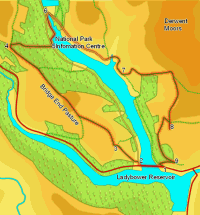
 This walk visits the hills that surround the northern branch of the Ladybower Reservoir, in the upper Derwent valley. The first part of the walk takes us onto Bridge-end Pasture, and offers stunning views west towards Kinder and Bleaklow, while the second half climbs up to the edge of the Derwent Moors and is dominated by Ladybower itself.
Ascent: 1,500ft/ 470m
Length: 7.8 miles/ 12.6km
Map: Explorer 01 Dark Peak Area
Last Walked: 8 June 2007
This walk starts from the roadside parking on the A 57 at Ashopton, just to the east of the bridge that crosses the northern spur of the reservoir. If this is full there is also car parking to the west of the bridge, but no paths lead to this car park, so only use it if absolutely necessary (we had to park there on our last visit, so can testify to the limited space on the verges).
Head west from the roadside parking, and cross over the bridge that carries the main road across the northern spur of Ladybower.
![]() Just past the bridge turn right onto the side road that runs alongside the northern spur of Ladybower. After a short distance turn left onto a footpath that leaves the road up a short flight of steps, passing through a gate into a small field.
Just past the bridge turn right onto the side road that runs alongside the northern spur of Ladybower. After a short distance turn left onto a footpath that leaves the road up a short flight of steps, passing through a gate into a small field.
Our path climbs up the right hand side of this first field, cuts diagonally across the second and then follows a clear path across the third field, passing through a farm gate into the fourth field. Here the path has been diverted to avoid Crookhill Farm. Turn right and head for a gap in the right hand (northern) wall of this field. Head diagonally to the left across this fifth field, aiming just to the right of a barn that forms the rightmost building of the farm.
![]() Our path now crosses over the road that leads to Crookhill Farm, then runs across the left hand side of the next field (with trees to the left), before reaching a small patch of National Trust land around Crook Hill.
Our path now crosses over the road that leads to Crookhill Farm, then runs across the left hand side of the next field (with trees to the left), before reaching a small patch of National Trust land around Crook Hill.
![]() A track runs along the edge of this open area. Turn right and follow it to the edge of the NT land, where we enter a large irregular field, sloping downhill from left to right. Our target is the north western (far left and highest) corner of the field. For the first 300 feet our track runs to the left of a stone wall. When this wall ends, the track swings away to the left, climbing gently. This track splits on a number of occasions - ignore any tracks that lead downhill to the right or too sharply to the left.
A track runs along the edge of this open area. Turn right and follow it to the edge of the NT land, where we enter a large irregular field, sloping downhill from left to right. Our target is the north western (far left and highest) corner of the field. For the first 300 feet our track runs to the left of a stone wall. When this wall ends, the track swings away to the left, climbing gently. This track splits on a number of occasions - ignore any tracks that lead downhill to the right or too sharply to the left.
![]() This track brings us onto the ridge that leads to Bridge-end Pasture and beyond, passing from the north western corner of the big field into the south eastern
This track brings us onto the ridge that leads to Bridge-end Pasture and beyond, passing from the north western corner of the big field into the south eastern ![]() corner of the next field. From here the route on is obvious - the track climbs up the ridge, reaching its highest point in the next field. From here there are superb views west towards Kinder Scout and Bleaklow. The track then continues on to the north west, running to the left of the forest that lines Ladybower for most of the way.
corner of the next field. From here the route on is obvious - the track climbs up the ridge, reaching its highest point in the next field. From here there are superb views west towards Kinder Scout and Bleaklow. The track then continues on to the north west, running to the left of the forest that lines Ladybower for most of the way.
![]() We follow the edge of the trees for nearly a mile, until we reach the north western corner of the forest. At this point two paths cross - our path along the ridge crosses a path that climbs up out of the valley to the left. Turn right and follow this path along the along the edge of the forest.
We follow the edge of the trees for nearly a mile, until we reach the north western corner of the forest. At this point two paths cross - our path along the ridge crosses a path that climbs up out of the valley to the left. Turn right and follow this path along the along the edge of the forest.
After a short distance turn right again onto a footpath that leads into the trees. This path runs straight into the trees for a short distance, then skips to the right before joining an overgrown forest track that runs right down the hill towards Ladybower. Stay on this track until we reach a footpath that leaves to the left. Turn onto the path and follow it to the lakeside road.
Turn left onto the lake side road, then after a short distance turn right onto a path that leads down towards the lake. Before we reach the shore, another path leaves to the left, and climbs up to a road that leads to an information centre. Pass to the right of the information centre, and follow a path that runs along the lakeshore to the northern tip of the lake. The path then runs along the Derwent, before reaching a minor road.
![]() Turn right onto this road, and follow it as it curves sharply around to the right, passes in front of the Derwent Dam and then heads down the eastern bank of the reservoir. Follow this road to the south down the eastern side of Ladybower.
Turn right onto this road, and follow it as it curves sharply around to the right, passes in front of the Derwent Dam and then heads down the eastern bank of the reservoir. Follow this road to the south down the eastern side of Ladybower.
![]() This road runs straight south for the next mile, before kinking sharply to the left to pass around a small bay. About a fifth of a mile further south a private road joins the road from behind and to the left, while a public footpath leaves ahead and to the left. Turn onto this path and follow it as it runs across the next field on a line of flagstones, before turning sharply to the left and climbing up towards a small cluster of buildings.
This road runs straight south for the next mile, before kinking sharply to the left to pass around a small bay. About a fifth of a mile further south a private road joins the road from behind and to the left, while a public footpath leaves ahead and to the left. Turn onto this path and follow it as it runs across the next field on a line of flagstones, before turning sharply to the left and climbing up towards a small cluster of buildings.
![]() Our path passes between these buildings then turns to the right. It runs across the hillside for a short distance, the turns left to climb steeply up towards the edge of the Derwent Moors, passing to the left of a small patch of woodland.
Our path passes between these buildings then turns to the right. It runs across the hillside for a short distance, the turns left to climb steeply up towards the edge of the Derwent Moors, passing to the left of a small patch of woodland.
At the end of the woodland the path climbs diagonally across the open moor, before reaching a wall running across the hillside. Pass through this wall, then turn right and follow a track that runs parallel to the wall around the valley of Grainfoot Clough.
![]() This path leads us to the rocky outcropping of Whinstone Lee Tor, where it curves around to the left, passes below the crags and brings us to a junction of six paths. Our route follows the path that runs downhill to the right, but for the moment we are going to ignore this path and visit Lead Hill, a great viewpoint overlooking Ladybower.
This path leads us to the rocky outcropping of Whinstone Lee Tor, where it curves around to the left, passes below the crags and brings us to a junction of six paths. Our route follows the path that runs downhill to the right, but for the moment we are going to ignore this path and visit Lead Hill, a great viewpoint overlooking Ladybower.
![]() To reach Lead Hill, take the third path from the left, running south west across a patch of level ground. After 800 feet this path reaches our viewpoint at a cluster of boulders, just to the right of the path.
To reach Lead Hill, take the third path from the left, running south west across a patch of level ground. After 800 feet this path reaches our viewpoint at a cluster of boulders, just to the right of the path.
After admiring the view return to the six-way junction and take what is now a left hand turn heading steeply downhill in a small gully. At the base of the gully turn left and follow the path as it curves around to the left, before passing through a large gap in the forest above our starting point.
At the edge of the woods turn right onto the minor road into Ashopton. Follow this road through the hamlet and back to our starting point by the lake..