 Kinder Scout is one of the most famous walking areas in Britain. It was the site of the famous mass trespass, one of the key moments in the development of the walking movement in Britain.
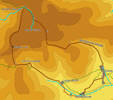
Kinder Scout is a flat topped plateau surrounded on all sides by steep slopes, with rocky crags on the western and northern edges. The top itself is covered with peat, and cut across by steep sides gullies, making it something of a maze.
The top of Kinder is a difficult area to cross. If you are not an experienced walker, turn back at the Downfall. If the River Kinder is in flood, turn back. If its foggy or wet turn back. If its dry and clear, then take a compass and enjoy one of the most unusual places in Britain.
Ascent: 1,675ft/ 510m
Length: 9.5 miles/ 15 km
Map: Explorer 001
Last Walked: June 2007
This walk starts from the car park on the road from Barber Booth to Upper Booth. If driving west through Edale, look out for the right turn just past Barber Booth. If you are driving into Edale from the direction of Mam Tor, turn left just as the road levels out.
![]() The Pennine Way crosses this road just before the buildings of Upper Booth. As the road turns right into the farmyard, continue straight ahead along a track, signposted for the Pennine Way.
The Pennine Way crosses this road just before the buildings of Upper Booth. As the road turns right into the farmyard, continue straight ahead along a track, signposted for the Pennine Way.
At the end of the valley follow the steep winding stair (Jacob's Ladder). There is an alternative track to the left, but Jacob's ladder provides the best views.
![]() The path up Jacob's ladder leads to a pass over the hills. At the top of the pass, turn right and head towards Swine's Back, an overhanging tor that is much more dramatic from below than once you reach it!
The path up Jacob's ladder leads to a pass over the hills. At the top of the pass, turn right and head towards Swine's Back, an overhanging tor that is much more dramatic from below than once you reach it!
![]() Just beyond the rocks at Swine's Back the path splits. Ignore the path that curves away to the right along the southern edge of the Kinder plateau and follow the left hand path as it climbs up towards the highest point on Kinder, at Kinder Low. From Kinder Low continue north along the edge of the plateau.
Just beyond the rocks at Swine's Back the path splits. Ignore the path that curves away to the right along the southern edge of the Kinder plateau and follow the left hand path as it climbs up towards the highest point on Kinder, at Kinder Low. From Kinder Low continue north along the edge of the plateau.
![]() The path takes us to Kinder Downfall. Here the River Kinder drops off the plateau, which turns north west. We now have to make a decision. On a foggy or wet day, turn back, return to the junction just beyond Swine's Back, and take the path along the southern edge of the plateau, rejoining our main route between steps 6 and 7.
The path takes us to Kinder Downfall. Here the River Kinder drops off the plateau, which turns north west. We now have to make a decision. On a foggy or wet day, turn back, return to the junction just beyond Swine's Back, and take the path along the southern edge of the plateau, rejoining our main route between steps 6 and 7.
![]() The route across the top of Kinder now follows the course of the River Kinder. There is a narrow path by the side of the river, but on most days the river bed itself is dry enough to walk on. Follow the river as it curves around to the right, and through the Gates of Kinder.
The route across the top of Kinder now follows the course of the River Kinder. There is a narrow path by the side of the river, but on most days the river bed itself is dry enough to walk on. Follow the river as it curves around to the right, and through the Gates of Kinder.
This is the difficult bit! After a bit this valley begins to split, twist and turn. At this point abandon the gully, and climb up onto the top of the peat. Once on top of the peat, head south east towards the edge of the plateau, taking care not to fall into another gully! A compass is essential here - it is very easy to get turned around.
![]() Eventually you should start to find gullies heading south. Find one that looks like it has been walked down recently and climb back down into it, always heading south.
Eventually you should start to find gullies heading south. Find one that looks like it has been walked down recently and climb back down into it, always heading south.
We should reach the edge of the plateau at the head of Crowden Clough, a steep sided valley heading down to Upper Booth. Here a clear path runs along the southern edge of the Kinder Plateau. Turn left onto this path, and head east around the top of the clough.
The main path continues around the eastern side of the clough. About half way along this path, another path heads east away from the clough. Turn onto the path and follow it to the top of Grindsbrook Clough.
![]() Grindsbrook Clough is a steep rocky staircase that climbs down the side of the plateau into the valley that contains the village of Edale. From a distance it looks intimidating, but it is actually quite an easy path, as long as you take care. The valley curves from side to side, hiding its full length and making it rather less intimidation. At the base of the clough, follow the path along the left had side of the brook, until it reaches the village of Edale.
Grindsbrook Clough is a steep rocky staircase that climbs down the side of the plateau into the valley that contains the village of Edale. From a distance it looks intimidating, but it is actually quite an easy path, as long as you take care. The valley curves from side to side, hiding its full length and making it rather less intimidation. At the base of the clough, follow the path along the left had side of the brook, until it reaches the village of Edale.
At the end of the Grindsbrook valley we reach the northern end of the only road in Edale village, close to the first of its two pubs. Continue south along the road through the village. ,
Follow the main road south through Edale. Just past the church, the road curves around to the right, then turns sharply to the left. Just as the road turns left, a footpath leaves to the right. Take this path as it heads across the fields, following the obvious line of stiles. The path slowly gets closer to the railway, which runs to our left. Just before Barber Booth, turn left onto a track and cross over a railway bridge. Follow the track into Barber Booth.
Once in Barber Booth turn left onto the road through Edale, then immediately right, heading west along the valley. Just outside the village, turn right onto the road signposted for Upper Booth, and return to the car park.