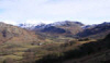
 This low level walk around upper Eskdale takes us to the edge of the highest ground in the Lakes, and on a good day provides impressive views of the fells around the top of the valley, and at the same time explores some charming lower level paths.
Ascent: 350ft
Length: 4 miles
Map: The English Lakes - South Western Area (OS Explorer Map Active) 
Last Walked:
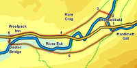
We start from the small car park at the foot of Hardknott Pass.
1: NY 213 011
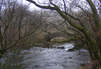
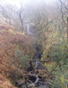
Head down the road from the car park. Cross the bridge over Hardknott Gill, then turn right onto the farm track leading to Brotherilkeld. Just before reaching the farm keep left and follow the footpath that follows runs upstream along the River Esk.
2: NY 212 014
Just after passing Brotherilkeld we reach a footbridge over the Esk. Cross this bridge then head across the next field towards Taw House Farm.
3: NY 210 015
At Taw House our route takes us into the farm yard, and then then left, leaving through a gate onto a track that runs south-west, on the edge of the high ground. Follow this track as it runs in a roughly straight line all the way to the road through Eskdale.
4: NY 201 099
Turn right onto the road, and follow it west towards the Woolpack Inn.
5: NY 188 009
Just after passing the Woolpack turn left onto a side road that heads down towards the river. Follow this road down to Doctor Bridge, cross the bridge and head along the track that runs east towards Penny Hill Farm. At the farm follow the diverted footpath that takes us around a field bypassing the farm yard. The path then runs past a second farm, then runs along the left-hand side of a series of fields, with the River Esk just to the left and the hillside climbing up to the right.
6: NY 203 005
After passing through a series of open fields we enter a wood. Ignore the path that branches off to the left here, and continue on to the east, following a path that has some woods to the left and the open fell side to the right. This path eventually joins the path coming down from Harter Fell, before reaching Jubilee Bridge and our starting point.