 This is a short walk that begins with a trip on the Coniston ferry, before returning around the northern shore of the lake. The start is practically good if you can catch the steam yacht Gondola on one of its circular trips, with a long loop south from Coniston to Brantwood.
Ascent: 200ft/ 60m
Length: 2.5 miles/ 4km
Map: Explorer 07 English Lakes South East
Last Walked: 7 October 2007
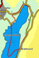
There is car parking at the pier used by the steam launch in Coniston.
Follow the path from the Brantwood landing up to the road that runs down the eastern side of the lake. Turn left onto the road and follow it past some woods.
![]() This path crosses two farm tracks. Just after crossing the second track look for an alley between two stone walls (on the left). Head down this alley into a small field. The path then runs into a larger field where it becomes much clears and the reaches another track. Follow this track onto a minor road.
This path crosses two farm tracks. Just after crossing the second track look for an alley between two stone walls (on the left). Head down this alley into a small field. The path then runs into a larger field where it becomes much clears and the reaches another track. Follow this track onto a minor road.
Turn left onto this road, which runs around the northern shore of Coniston.
![]() This road ends at a T-junction. Turn left here and follow the path, which now runs behind a hedge on the opposite side of the road to the lake.
This road ends at a T-junction. Turn left here and follow the path, which now runs behind a hedge on the opposite side of the road to the lake.
Follow this path until it passes a group of buildings. Soon after this, turn left through a gate onto a track that heads towards the lake shore. Follow this track down to the water and then follow it as it runs along the lake shore back to Coniston Pier.