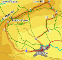
 Although this walk starts in Castleton, one of the busier villages in the Peak District, it manages to avoid most of the crowds, all following the well paved path to the top of Mam Tor. Instead it curves around the head of the Hope Valley, climbs up to Hollin's Cross, where the old packhorse trail crossed into Edale, then heads east along the ridge towards Lose Hill. This is one of my favourite viewpoints in the Peak District, with dramatic views into Edale, down the Hope Valley towards the Derwent and out towards Kinder Scout.
Ascent: 1,200 feet/ 360 metres
Length: 5.3 miles/ 8.5 km
Map: OS Explorer Map 1 Dark Peak Area
Last Walked: April 2007
The road from Castleton to Chapel-en-le-Frith used to run around the front of Mam Tor. However, the front of Mam Tor is very unstable and after repeated landslides the road was closed. The section nearest to Castleton is now lined with parking placed. Our walk starts from here.
Start from the roadside parking west of Castleton. Follow the old main road as it curves around to the right, towards the front of Mam Tor and Treak Cliff Cavern. Ignore the side road that leads up Winnats Pass.
Follow this main road until the tarmac runs out at Mam Farm. The final stretch of the road runs across the front of the Mam Tor landslide, which is very obviously still on the move. The road is open as far as Odin Mine, where a small cave is open to the public, and is maintained as far as the farm, but above that no sign of the tarmac remains.
At the end of the tarmac, a track leads down hill towards Mam Farm. The right of war follows this track, but we will take the permissive path that runs above the farm. Pass through a gate to the left of a National Trust sign, and follow the obvious path as it winds its way around the hillside, slowly climbing up the side of the slope.
This path runs along the top of Barker Bank, then down into a slight dip, before climbing up the side of Back Tor. On Barker Bank the path runs to the south of the wall. At the bottom of the dip before Back Tor, cross over to the left (north) side of the wall, and continue in the same direction. Follow the obvious path that runs up the right side of Back Tor, taking advantage of the steps that have been built into the slope. The top of Mam Tor gives us about the best views back towards Mam Tor. From the top of the tor, continue east along the path towards Loss Hill.
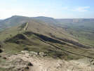
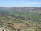 We are now at the main objective of our walk, the summit of Lose Hill or Ward's Piece. This is one of my favourite viewpoints in the Peak District, offering panoramic views of the Vale of Edale, the Hope Valley, the Kinder plateau, the Derwent valley and the moorswest of Sheffield.
Once you are ready to move on, follow the obvious path heading south east down the hill. Castleton is clearly visible to the right as we descend from the summit.
Continue on this path until it crosses over a first stile. Here we leave the main path, which now curves around to the left, instead crossing a stile in the fence to our right. Once over the style, turn left and follow the path alongside the fence we have just crossed.
Our path runs alongside the fence for six hundred feet, then swings out to the right, before turning back left and heading towards a farm. Just before we reach the farm, a signposted foot path leaves the track, and heads down the slope to the right, heading towards a small gate in the corner of the field. Pass through this gate and head south along the edge of the next field.
Soon after entering this field, we reach a stile to our right. Cross over this stile, and head straight out across the next field. At the other side of this field you will find a farm track. Follow this track along the northern edge of the next two fields, ignoring the track that heads south after the first field.
At the end of the second field, follow the path as it turns left along the side of the next field, running along the right of the hedge and heading towards Riding House Farm. Just before reaching the farm, the path switches into the field to the left of the hedge, and passes the farm. A steep gully separates this field from the farm yard. At the southern end of this field, follow the path down into the gully, across the stream and back up some steps into the next field. At the top of the steps turn left and head south along the edge of the field.
After two fields we reach a lane running behind the Losehill Hall National Park Study Centre. Turn right onto this lane, and follow it until it turns sharply to the left. At the corner you will find a farm gate, with a path closed sign, leading into the field to the north of the lane. Ignore this gate, instead pass through a narrow stile just to the left of the gate, leading into the field that runs south alongside the lane we are now leaving. Follow the path along the northern edge of this field. Cross over a small stream at the end of this first field. Our path continues on in the same direction across the next field, cutting across a corner of this irregularly shaped field, before joining a farm track in the south west corner of the field. Continue straight ahead along this track.