 This walk takes you to the top of the Berwyn mountains, a beautiful but relatively unknown range of heather clad mountains, just south of Llangollen. The Berwyns peak at over 2,700 feet, but this walk starts half way up.
Ascent: 1450 feet/ 450 metres
Length: 8 miles/ 13 km
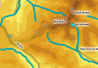
Map: OS Explorer Map 255 Llangollen and Berwyn
Last Walked: 18 April 2006
The car park entrance is just north of the county boundary, and only a few hundred feet beyond the top of the climb out of the valley to the south. Look for a small mound on the east side of the road - this is actually a bank around our car park.
 The only real navigation problem on this walk comes at the very start, where it is not immediately apparent from the car park where the path actually starts.
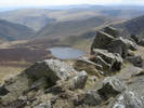
To find it, climb up onto the bank around the car park and follow it around to its eastern edge. From here our path is clearly visible - a wide grassy (or muddy) strip in the heather. This first section of the path runs east, with Moel Sych and Cadair Berwyn clearly visible in front of you.
Our route is nice and simple - there is only one path along this ridge, clearly visible when underfoot, and heading along the highest part of the ridge.
The only real navigation problem on this walk comes at the very start, where it is not immediately apparent from the car park where the path actually starts.
To find it, climb up onto the bank around the car park and follow it around to its eastern edge. From here our path is clearly visible - a wide grassy (or muddy) strip in the heather. This first section of the path runs east, with Moel Sych and Cadair Berwyn clearly visible in front of you.
Our route is nice and simple - there is only one path along this ridge, clearly visible when underfoot, and heading along the highest part of the ridge.
After a short distance our path crosses over a track. Here you will find an information board, complete with a map of the Berwyns and some notes on what to look out for on the hills.
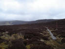
This first section of the walk would be very very wet, if it were not for the boardwalks. If you don't soon find these soon after crossing the track (see picture above for an example), then you have missed the path!
 Keep following the clearly visible path along the highest ground (the modern OS maps show the right of way much further south, but the sign back on stage one shows the current path). Ahead you will soon see a fence climbing up from the right and ending at the ridge line. Our path runs along the left hand side of this fence, all the way to the summit of Moel Sych.
 The cairn marked on the OS map is actually a hollow shelter, which came in very handy when we last did this walk - a particularly windy April day.
The Berwyns are covered by one Explorer map