 This walk passes through three very different villages - the large busy village of Balsow, the show piece estate village of Edensor and the quiet village of Pilsley. The first part of the walk is dominated by Chatsworth House and its estate, while the second part heads into the quiet rolling hills west of the Derwent.
Ascent: 640ft/ 200m
Length: 5.5 miles/ 9km
Map: Explorer 024 White Peak District
Last Walked: 17 May 2007
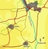
Our starting point is the car park on the A 619 at the eastern end of Baslow
![]() Turn right out of the car park onto the side road that runs across the entrance. Follow this road as it runs east towards a bridge that crosses the Bar Brook.
Turn right out of the car park onto the side road that runs across the entrance. Follow this road as it runs east towards a bridge that crosses the Bar Brook.
![]()
![]() Cross over the bridge, then turn right onto the track that runs along the left bank of the brook. At the edge of the village we pass through an elaborate gate and enter Chatsworth Park. Follow this track as it runs south through the park, keeping the Derwent to the left and the park to the left. As we head south, Chatsworth House comes into sight to the left.
Cross over the bridge, then turn right onto the track that runs along the left bank of the brook. At the edge of the village we pass through an elaborate gate and enter Chatsworth Park. Follow this track as it runs south through the park, keeping the Derwent to the left and the park to the left. As we head south, Chatsworth House comes into sight to the left.
![]()
![]() Follow this track until it reaches the main road to Chatsworth House, just past Queen Mary's Bower (see picture left). Cross over the Derwent on the road bridge. Just beyond the bridge, on the west bank of the Derwent, take the footpath that leaves the road to the left.
Follow this track until it reaches the main road to Chatsworth House, just past Queen Mary's Bower (see picture left). Cross over the Derwent on the road bridge. Just beyond the bridge, on the west bank of the Derwent, take the footpath that leaves the road to the left.
![]()
![]() Follow this path as it climbs up and over the southern flank of a low hill and then drops down towards the estate village of Edensor. Cross over the main road and enter Edensor. Follow the main road through the village (passing to the right of the church).
Follow this path as it climbs up and over the southern flank of a low hill and then drops down towards the estate village of Edensor. Cross over the main road and enter Edensor. Follow the main road through the village (passing to the right of the church).
![]() Turn right onto this road (Handley Lane), and follow it as it runs down hill along the top of a bank, with great views across Handley Bottom to the left.
Turn right onto this road (Handley Lane), and follow it as it runs down hill along the top of a bank, with great views across Handley Bottom to the left.
After three quarters of a mile, Handley Lane reaches a bigger road. On the far side of the road a footpath heads north across the next field, running in the same direction as Handley Lane - take this footpath. After cutting across the corner of the first field, the path joins the southern end of a farm track - follow this track.
![]() After a quarter of a mile the track reaches a small wood and splits in two, with branches passed either side of the trees. Take the right hand branch, with the trees to your left, and follow it into Pilsley. Once in the village the track becomes a road (see picture, right). Follow this road to the main road. Here turn left onto the main road and follow it down hill out of the village to the north east.
After a quarter of a mile the track reaches a small wood and splits in two, with branches passed either side of the trees. Take the right hand branch, with the trees to your left, and follow it into Pilsley. Once in the village the track becomes a road (see picture, right). Follow this road to the main road. Here turn left onto the main road and follow it down hill out of the village to the north east.
![]() About 600 feet past the last buildings in the village a footpath leaves the road to the left. Follow this footpath to the far end of the first field. Here the path passes a clump of trees, and then passes through a gate into the field to the right (see picture). Follow the path as it drops diagonally down a grassy bank towards the A 619.
About 600 feet past the last buildings in the village a footpath leaves the road to the left. Follow this footpath to the far end of the first field. Here the path passes a clump of trees, and then passes through a gate into the field to the right (see picture). Follow the path as it drops diagonally down a grassy bank towards the A 619.
At the bottom of this bank, our path reaches the A 619, crosses over the road, and climbs diagonally back up the opposite side of the valley, reaching the top right corner of the first field.
Here a stone wall continues on in the same direction as our path, with the path itself on the left hand side of the wall, running around the right hand side of the next field. The OS map shows this as being the first of a series of small fields, but in fact all three of these fields have now been merged into one. Our path follows the right hand side of this field all the way to another small road - first heading north east along the wall, then turning a little to the right, and running east, still along the wall, then finally turning to the left and heading to the road.
![]() Turn right onto this road and follow it for a very short distance, until another footpath is signposted leaving to the left. Follow this path as it heads across the middle of the next field. We reach the opposite wall at the corner of a dogleg. Turn right and follow the wall into the north east corner of the field, heading back towards Baslow, which is now visible across the fields. Follow this path as it runs east through the next few fields (one long and then two short), and then drops down a small bank into Baslow.
Turn right onto this road and follow it for a very short distance, until another footpath is signposted leaving to the left. Follow this path as it heads across the middle of the next field. We reach the opposite wall at the corner of a dogleg. Turn right and follow the wall into the north east corner of the field, heading back towards Baslow, which is now visible across the fields. Follow this path as it runs east through the next few fields (one long and then two short), and then drops down a small bank into Baslow.
Our path reaches the outskirts of Baslow at Bubnell Road opposite a bridge over the River Derwent. Cross over this bridge to reach the main road through Baslow. Turn right onto this road. Follow it past the church, and to a roundabout. Take the left hand turn at the roundabout (the A 619 to Chesterfield) and follow it back to the car park.